July 3-6, 2008
What a Way to Celebrate July 4th
Trip Stats:
- Distance: About 14 miles on trail, 5 miles off trail and scrambling (roundtrip)
- Elevation gain: About 5,000 feet (the trail starts at 8,400', then descends to 8,000' and Ritter lies at 13,150')
- Time: One day to Ediza lake camp and another day departing, plus 13.5 hours roundtrip to summit (for us)
- Trail and Trailhead: Agnew Meadows trailhead to Shadow Lake Trail (Permit information and dates with filled reservations)
- Difficulties: Moderate (35 degree) snow, third class loose rock in a tight chute
- Highlights: Being on top of the tallest mountain around, a quite fun route!
Overview:
Visible from Hwy 395, the top of Mammoth Mountain, and other surrounding areas, the peaks of Ritter, Banner, and the Minarets hold the attention of mountaineers like very few other summits in the Sierra. Much less sustained than the 3rd class of the North Face, the Southeast glacier route on Mount Ritter offers varied and relatively solid scrambling.
Description
It being July 4th weekend, we were only able to get permits for 6 people to start July 3rd. Roy could only leave at noon, so that meant that we would be hiking to Ediza Lake in the dark. Sort of silly, but also sort of fun. Unluckily, one of our crew, Adam, had his car towed that morning and wouldn't be arriving until at least 10pm (we started walking at 9pm) so he and Jen Hopper opted to get a walk-in permit the next day.
After the mandatory shuttle down to Agnew Meadows stopped at 8pm, we could simply drive down into the valley with our own cars. So at 9pm, Jeff, Roy, Brandon, and I started out on the Shadow Lake trail toward Lake Ediza. Though easy to follow in the daytime, the trail has a few forks that require attention in the dark. (A lesson Roy and I learned the hard way a few years ago.)
At around 1am, we successfully arrived at the south shore of Lake Ediza, and, after heartily scouting our options, found that our best way across to the campsites in the trees on the east side of the lake was to... ford the freezing cold river feeding into the lake. We shed boots and socks, plunged in up to our knees, oohed-and-owwed our way across, crawled up the opposite bank, and enjoyed the 'invigorating' numbness of our feet and ankles. And so was the flavor of the trip begun. We were in our tents a bit after 2:30 am.
The next morning we slept in and lazily put off 'snow school' for Brandon and Jeff until 3pm. Of course, in the daylight, we found a slightly easier way across the river we had forded that morning. We dubbed the new crossing 'the leap of faith'. At least it didn't involve taking boots off.
And after step kicking, self arresting, and cramponing on a measly little snowfield south of camp, Jen and Adam appeared. They had gotten the last two walk-in permits and showed up in time for dinner on July 4th. We all returned to our basecamp on the west shore of Ediza. Dinner followed, with a cake in celebration of Adam's birthday, then early to bed.
We arose for a 4am departure. Jen and Adam opted out of the climb that morning, as they wanted to sleep in and practice locally for their climb of Mount Humphreys the next weekend. So Jeff, Brandon, Roy and I were again hiking together in the dark. Here is Ritter arising in the near-dawn:

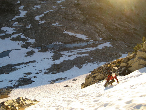
It began to get light as we reached the cliff bands below the Southeast Glacier. Despite the lack of snow at camp, the bowl between the Ritter-Banner saddle and the south flanks of Ritter was still fairly well snow covered. This meant we faced snow climbing on the cliffs below the glacier, and a bit of patchy 2nd class rock in crampons. (In later season when the snow melts, these cliffs are class 3 rock.) Here is Roy on the first part of the still-frozen morning snow as the sun rose:
We finally gained the bowl a bit to the east of the toe of the glacier. The bowl (I believe it is listed as the 'Clyde variation' to the SE glacier direct) then leads easily to the toe of the SE glacier on either snow or (as we opted for) ledges on rock bands.
Once on the glacier, the route is pretty easy for a while - walk up the low-angle base of the glacier until the end of it on climber's right. Then, a number of chutes (and cairns) present themselves to continue on rock.
When ascending, we found a nearly-all second class rock route to the saddle south of Ritter's summit. It followed ledges on a subtle rib between the well-cairned chute to climber's right, and the loose scree to climber's left.
Once below the saddle south of the summit, the snow was soft enough to kick steps, so we left the crampons off and continued on snow and rock to the top. Having fun despite (or rather because of) the altitude, we called the continual effort of climbing 'kicking the pig'. The alternate meanings for that saying got worse and worse (better and better) as the day wore on. At long last, we were on the summit at 10:45 am, the pig having been well kicked. Here is our goofy summit shot, Roy on left, Jeff in the middle, Brandon on the right:

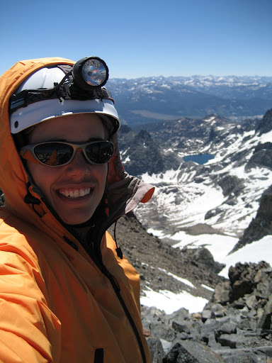
Here is my self-portrait on the summit:
After glissading down the snow and hopping down the rock back to the chutes just below the saddle, some debate ensued as to where we came up from the glacier. In the end, we opted for the well-cairned gully we had avoided on the way up. The new gully ended up having more class 3 and looser rock than our ascent route. Thus, it took longer to get down since we moved one at a time through the loose rock sections. Here is Jeff entering one of the short class 3 spots:

After escaping the tight gully, we ignored the 'cairn gnomes' and proceeded down the wide talus field to the glacier. Here are Jeff and Roy looking small against the talus and snow below:

Down the glacier we went, then all the way back across the bowl toward the east before descending the snowy cliffs from the morning. Both Jeff and Brandon enjoyed working on their newfound snow skills, so they descended one at a time and kicked their own steps. A fun way to end the climb.
We descended on trail back to Ediza lake, into the heat and the mosquitoes. Jen and Adam excitedly returned from practicing on Volcanic Ridge to the south of Ediza. We swapped stories and were happy to hear everyone had a great day. Then we all had dinner and flopped into bed.
The next day, we slept in, packed up, and hiked out in the afternoon heat. The four of us who had hiked in the coolness of the dark at the beginning of the trip marveled at how well that worked out as we sweated back up to the Agnew Meadows trailhead. At the cars, we packed up, hugged each other, and departed. What a great trip.
If you like, you can see all of my photos from this trip. Congratulations to Jeff and Brandon on their first Sierra peak, and as always, thank you to Roy, the love of my life, for sharing this adventure with me.

No comments:
Post a Comment