The Long Way Home
July 23-27, 2008
Trip Stats
- Distance/Gain: 7 miles, 7,000' one way
- Trailhead: Scott Paul Trailhead (603.1) off of FS Road 13. (Directions: Take Hwy 20 East to Baker Lake Road, 12 miles to a left on FS Road 12, 4 miles to a right on FS Road 13, trailhead at end of road.)
- Time: One day to Crags View base camp, one crevasse rescue practice day, one summit day (24 hours), one rest day, one descent day (for us)
- Difficulties: Grade III, 40 degree snow, glacier travel
- Highlights: Beautiful, challenging, a less-travelled route
Overview
Mount Baker dominates the skyline of Northwestern Washington. In an area that holds the world record for snowfall in a season, it has interesting glaciers and wild weather. Though Baker is usually climbed by the Easton or Coleman/Demming routes, the Squak glacier offers an interesting alternative route or alternative approach to the Easton route. It is a popular ski route as well as a climbing route.
Notes:
- You can view all of my photos for this climb, as well as all of Jen's photos.
- You can also view our gear list from the climb, with my comments
- You can read the route descriptions for the Squak glacier route and the Easton glacier route on Summitpost.org
- The Forest Service does not require a permit for climbing Mount Baker; however, they do require a Northwest Forest Pass. They also maintain a page with current climbing conditions.
There are many times in one's life where things both work out well and don't work out well. This was one such time. The route was beautiful, challenging, complex, and ultimately one of the most rewarding things I've done in my life. The following account intermixes both trip report and personal account. I hope the trip report is helpful; I hope the personal account comes off as honestly as I intended. I felt I could not write one without the other.
Jen Hopper and I had been planning a trip to the Cascades for a while. She had been too busy to look at options, and so at the last minute I proposed the Squak on Baker which I had done a couple of times in June a few years ago. I remembered it as a slightly steep but enjoyable glacier climb, and given Jen's extensive experience on glaciers (Denali, Rainier, South America) I felt it would be a good fit for both of us.
We met at SeaTac and loaded our climbing gear into a rental car and headed off. We purchased bamboo stakes for making climbing wands at a garden store on the way to Seattle for $9 for 50 stakes, a worthwile detour. Then we stopped by the Flagship REI (not recommended for a quick stop as Seattle is rather busy - maybe try Renton instead) for fuel and maps and a few other odds and ends.
On the way to the trailhead, we stopped by the ranger station on Hwy 20 to pick up blue bags and sign a voluntary climbing register before continuing on to the Baker Lake Road turnoff. There are a number of campgrounds near Baker Lake which allow walk-in registration and we easily found a spot for the night.
The next day (July 23) dawned rainy and cold (54 deg F). Jen, being anxious about packing, got me up earlier than I would have liked, and her anxiousness and my tiredness set the tone for the day and perhaps the trip. We packed, drove to the Scott Paul trailhead, and started walking with our heavy packs. After negotiating a few downed trees, the snow began in earnest at about 4500'. Visibility narrowed to less than 200', it started raining lightly, and we walked in a frustrating fog (both literally and metaphorically) generally north toward Crag's View. I set two wands and took a GPS track before we even reached the glacier.
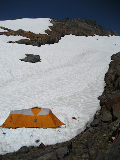
At around 7pm, we reached the base of Crag's View (the View itself is a rocky outcrop; camp lies right below it) and set up our tent. Here is the tent below Crag's View; the photo was taken on the much clearer second day:
Our plan was to practice team arrest and rescue the next day, as this would be our first time mountaineering together despite our extensive experiences canyoneering together.
We heard reports that the mountain had not been freezing overnight (the freezing level had been above 10,000 feet for nearly a week before), but to actually see such a phenomenon in person was a weird experience. No ice, no crampons. Slush became the norm around 11am. At breakfast, the sun began baking the snow in earnest. I awoke early and watched a pair of skiers pass our camp and ascend onto the Squak. About 10am, we flaked out the rope to walk over to a practice site.
After the frustrating navigation and tone of the previous day I felt unsure about whether I wanted to continue climbing with Jen, and this second practice day didn't help. Despite her having much, much more time spent on glaciers than I did, she was unexpectedly unprepared. I found myself having explain how to keep the rope taut. I explained how to tie in. I explained how to set up prussiks. I explained two-person crevasse rescue.
The whole day, I felt this weird buzzing in my ears. Something seemed wrong, and of course sitting on my couch now writing this, I understand better. However, at the time, I was unable to reconcile the fact that Jen said she was ready to help actually lead the route and yet my eyes could see that the most basic elements of glacier team travel seemed completely new to her. It wasn't Jen's fault. It wasn't my fault. We are great canyoneering partners and great friends. But on the mountain, it was a total misunderstanding.
I'll say now that at that point, honestly, one of us should have seen that and we should have gone home. It was obvious that the two of us shouldn't have been climbing together. I'll be realistic: we were very, very lucky the whole summit day. With only a handful of experiences, I am fairly new to leading on glaciers, especially less-travelled glaciers where there is not a boot-pack to follow. And a new glacier leader, plus an inexperienced second in a two-person team, on a late-season and broken up slushy glacier was just asking for trouble.
But standing next to the Squak, being able to smell the cool wind coming off of it, I wanted so badly to be standing upon it. So we glossed over the details of practice, and I didn't press the issue. We came back to find Jen's food spread around by ravens, and we cooked dinner and packed and went to bed. I felt very angry and very scared and stayed up most of the night outside the tent on the rock ridge near us, watching the stars, and repeatedly looking at the map and the mountain in the darkness.
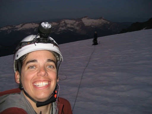
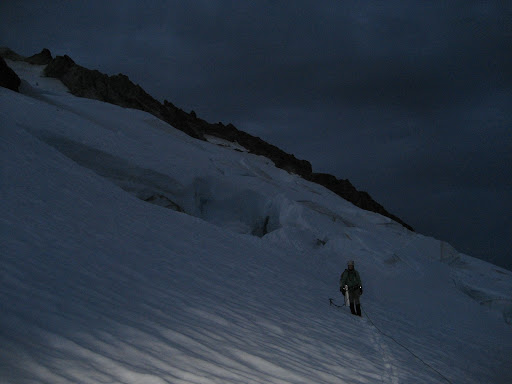
We awoke at midnight and began walking roped at 1am. I started a GPS track from camp; we carried the 48 wands remaining after placing two on the fogged approach. It felt good - wonderful, in fact - to be climbing in the dark on a vast expanse of snow. We easily gained the toe of the Squak via subtle ridges to the NE of Crag's View. I could hear the waterfalls torrenting out from the terminal moraine below us until we climbed high enough to hear nothing but wind and darkness. It was amazing to be on a glacier again: I was honestly and truly happy. Here we are spread out at a rest break:
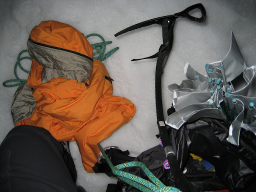
After the toe, I led up and northwest toward the connection between the Easton and Squak. The ski tracks from the previous day's skiers were sometimes visible, and sometimes not. The Squak nearest the rock between it and the Talum glacier was most broken up until about 8500', so I stayed more toward the Easton until that elevation. We crossed a few large crevasses on good snowbridges between 7800' and 8500'. My world was reduced to a rope, a mountain, and a small pile of gear. Here is my whole world spread out at a break:
At 8500', I faced a choice, I could lead left (west) onto the main body of the Squak, or right (east) of the rock prow sticking out about two-thirds of the way on the right (east) in the Squak. (If you aren't subscribed to Trails.com, use Lat/Lon 48.7597859, -121.8136712.) I was about to go left (where we would have found a huge unpassable crevasse, I found out later) but then I saw ski tracks to the right in the faint sunrise. So we went right.
It was obvious that the right-hand choice was very toothy and broken, maybe unpassable. The climbing angle was probably about 35-40 degrees from 8500' to 9100'. Due to the late season, there was more crevasse than snow continuum. The first snowbridge we crossed at 8500' was quite precarious, and because of the exposure above that crevasse (and the many subsequent crevasses) I placed pickets for the next 600 vertical feet. From my journal I wrote:
"I chose the right-hand option. And what a choice it was. Constant exposure, precarious snowbridges, enormous crevasses. And steep... One memorable bit of leading involved straddling a serac between two crevasses and humping my way over a hundred feet across the ridged top to rock on the other side. Jen called it 'riding the snow pony'. The crevasses on either side twisted in icy turmoil down into blackness - I called it petrifying."As with any late-season glacier, we walked more out of a straight line than in one, but the broken section in those 600' was especially non-direct. Most amazing to us were the signs of the skiers' passage the day before. That bit of the mountain demanded a lot: creative anchoring, patience, boldness, and - perhaps most demanding of all - three hours of our day.
At 9100', we popped out of the toothy body of the Squak and enjoyed a few hundred feet of relatively easy and uncrevassed climbing on the Easton. The relief of simply running uphill on snow was absolutely lovely! But at that point, I had been kicking steps for three thousand vertical feet of soft snow and had felt very in over my head leading the broken section of the Squak. And we hadn't even reached the Roman Wall.
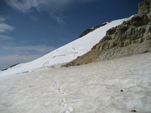
We crossed another tenuous snow bridge to reach 'The Pooch', which is the bit of rock forming a saddle right to the side (west) of the fuming summit crater. Here, we could see the Roman wall looked very broken, especially on the climber's right side where we were. Here is a photo from before the Pooch:
Three huge crevasses nearly spanned its entire base, and more partially cracked its midsection. I enjoyed a few hundred feet more of unbelayed climbing before again committing to setting picket after picket.
I weaved back and forth across the upper sections, trying to subtly follow less steep ridges (drifts and folds in the glacier) to minimize the chance of a fall in the very soft snow and our exposed position. Also from my journal:
"With the snow as soft as it was, many of our protection options were non-ideal and step kicking was very strenuous.... Our 11:00 am turnaround time came and went. Jen wanted to push on, seeing as we were 'so close' (we weren't) and I didn't care. The climbing was beautiful, and honestly, I think continuing upwards was much easier mentally than to think about leading back down all that scary and sketchy crap on the Squak that I'd led up..."Regardless, when we finally reached the summit, I remember not caring. I'd never felt that way about a mountain before. I'd always felt at least a little proud at the top of a mountain, but that time on Baker, I felt nothing about the summit at all.
Instead, all I could feel was how much my legs hurt after kicking 4500 vertical feet of steps (that is, it would have been 4500 feet if we had climbed straight up instead of weaving around crevasses) and how tired my arms were after pounding in all those pickets, and how much I didn't want to down climb all of those melting snowbridges. Jen insisted on taking a lot of photos. I felt like I was in a bad dream. The time was 1:00 pm. I think I said it best in my journal:
"When we finally reached the summit I didn't even care. My mind wasn't on top, it was off somewhere else, already working its way backwards down all those belays. It was so hot I could almost hear our snowbridges melting. I didn't feel halfway to anywhere. In fact, I felt like the hard and dangerous climbing was about to begin."Despite the stress, some things were going well. The climbing was gorgeous and pure. We had the mountain entirely to ourselves. Our 'per pitch' time (two rope team running belay lengths) got reduced to five minutes per pitch. And regardless of my trepidation of leading on a glacier, with the intermittent help of the ski tracks, I had successfully found a route to the top. Now all we had to do was get home.
The downclimb of the Roman Wall was a blur. More belays. Plunge stepping. Jumping two crevasses that had opened up. We reached the Pooch, and the snowbridge there had fallen in. I climbed into the crevasse and tentatively touched the collaped blocks. Solid, at least for the time I could scramble across and out.
After some debate about traversing all the way across the Easton to find an alternate descent to the toothy part of the Squak, I made perhaps my most autocratic decision of the day to downclimb the Squak. I didn't want any more glacier routefinding that day, especially routefinding downhill on a new route in the heat of the afternoon.
I thought of beta we had gotten from the rangers before leaving - that the primary snowbridge on the Easton was about to collapse. I had visions of wandering around on the Easton for hours, failing to find an alternate descent, and then me having to lead down the Squak in the dark. That decided it: the Squak would go in reverse, or we would bivy.
I led back across the 'white pony' serac (now slush), losing a carabiner into the depths of a crevasse. I led down around all the snowbridges that had thinned and shrunk during the day, belaying the whole time. Then, to my disappointment (but not surprise), the snow bridge at 8500' had collapsed. It was the only thing that stood between us and the relative ease of of the lower 2000' of the Squak.
So I led down and around an alternate route, much steeper, using up all of our protection and having Jen re-tie 20' down the rope from the slack in her pack (while I was mid-pitch!) and anchoring off my tools at the end. Yikes!
We exited the technical section of the Squak at around 9pm. Jen dug around in her pack for her headlamp, and ended up dumping her rain jacket in a crevasse. I threw up out of relief while waiting for her: the hard climbing was over. Here is a picuture of the lower toothy part of the Squak as we exited:
The GPS enabled us to pick up all of the approximately 35 wands we'd placed on the glacier. However, that infernally weird piece of equipment mis-placed our track by a MILE at one point, which I followed for a full 300 feet before realizing it didn't feel right. I struggled to keep focus as I looked for our footprints and our wands, kept a lookout for crevasses, kept slack out of the rope from the bottom, and followed what help the GPS could offer.
We arrived at camp at 1:00am (24 hours after leaving), re-pitched the tent, ate food, and crawled into our sleeping bags to awake at 6pm that evening. I awoke once to chase ravens away - they had figured out how to open the toggle on my stuff sack even under a pile of heavy rocks. We ate again, and went back to sleep. It rained all night, but we were actually in a pretty upbeat mood after making it back to camp safe and sound and with nothing worse than some dehydration and sore muscles. The next day I wrote in my journal:
"Jen freely admitted that it was the hardest climb she'd done. I sorted through my mixed and tangled emotions to realize that it was the hardest climb I'd done too, much less unintentionally and near-unwillingly guided, and all things considered I was pretty proud....I learned how far I can push myself, which actually felt great! I was so scared the night before, and the entire summit day...and I'll say most of it was luck but some of it was hard work and pulling through."We packed up and started hiking down in low visibility again, marveling at how lucky we were to have good weather for the summit. The snow had melted considerably during the days we were up there, easing the task of finding the trail. We reached the trailhead in early afternoon in the rain. Jen and I did it. I still don't know whether it was worth it, but I have rarely felt so lucky or grateful in my life.

No comments:
Post a Comment