June 21, 2008
Fun Summer Day Canyoneering Adventure
Trip Stats:
Roundtrip Distance: About 5 miles
Start/End: Vogel Flat Road (East Picnic Area) off Big Tujunga Rd
Gain/Loss: 900ft / 275m
Time: 7 hours (for us)
Difficulties: 5 rappels, some downclimbing and awkward tree 'scrumbling',
Other Information: Chris Brennen's Writeup
Overview:
Though Chris Brennan gives this canyon only two stars, this canyon shines in the summer when its shade and water are welcoming on the hottest days. It isn't as 'clean' as some of the super-classics like Rubio or LSA (i.e. there are lots of downed trees, etc), but with the interesting basic problem solving, overhanging sides with beautiful dripping hanging fern gardens, and clear water (this canyon does not seem to be a pond scum farm due to its shady nature), Vasquez canyon has a charm all its own.
Canyon Description:
After some missed turns in the car we found the parking lot and packed up. For reference, Big Tujunga Road is located off the 210 Freeway by taking the Sunland Ave exit in Sunland, heading East on Foothill Blvd (Foothill = the other name for Sunland Ave) until Oro Vista Ave, and then taking Oro Vista North until it turns into Big Tujunga.
The trails in Chris's description were in good shape, though in the past they sometimes haven't been, due to overgrowth and flood. This time, we were lucky to follow the trail all the way up the Big Tujunga, up the ridge, and to the fir grove just West of the canyon drop-in. To my surprise, the Big Tujunga was dry, dry, dry! Also, the heat was quite oppressive in the morning on the ridge hike up, despite the intermittent shade and our relatively early start.
But once in the canyon (someone has placed a large cairn near the drop-in entrance), shade and a small trickle of water greeted us....relief.
- At the first drop (~10ft) we downclimbed the hollow downed tree that has been stationed there for many years - very neat in higher water when the flow goes through the tree itself!
- At the awkward second drop (~10ft) we set up a handline on the very large fallen and forked oak log that has been more recently placed there.
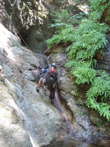
- After a bit more scrambling, we came to the first rappel (~30 ft). I've not solved this rappel the same way twice - sometimes having a wedged log to tie off, sometimes scrambling up a loose and exposed slope to canyon right to a tree, but this time we found neither log nor safe access to said tree. Thus, we made a rockpile in the streambed, tied off the back rock, and used that. Probably the most interesting problem of the day.
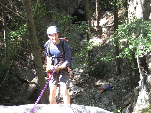
- Immediately after, we came to the second rappel, off of a dead but still well-rooted tree on canyon right. This rappel was shorter (~12 ft) and easier to set up, a relief after the rock pile. Here is Keith on the rappel:
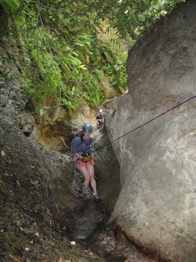
- Some more boulder hopping and under-tree ducking brought us to the third rappel (~30 ft) which was anchored off of tree roots to the right (very cool). Here is Kristie heading down:
- The canyon then relents in this steepness for a little while but various short downclimbs under and over large trees continued
- Finally, the double rappel at the end of the canyon appeared. The first of the two rappels goes down about 15 ft, into a short, water filled pool, and then down another seven or so feet to the top of the last rappel. The last rappel (~70 ft) anchors off a tree on canyon left. Here is a view from the top of the last rappel:
This canyon changes a lot over time. With the exception of the last two rappels, I remember all the other rappels each being variously downclimbable due to treefall piles in the right places, but at other times (like this one) all are rappels.
In addition, the first rappel anchor changes with the fickleness of the latest flood. Huge logs, rockfall, and other features change position much more than I've seen in other canyons. Odd, as this canyon is not scraped clean from obvious flashing.
Overall, a great day. In addition to those above, you can view all six photos from the trip. Thanks to Kristie and Keith, this was my first canyon I did with them, and it was fun.

2 comments:
Nowadays, after the Station Fire and the debris flows that followed, much of Vasquez is downclimbable. The West fork of Vasquez creek is a nicer descent, and just as shady. The trail from Big T is hard to find if you don't know where it is, but once you get about 400 ft above the river bed you'll cross two tributaries to Vasquez. Drop into the last one before the Grizzly Flat plateau (the final 100 yards or so is partially blocked by a tree) and follow it down. Not as many rappeals along the way, but the final 300 ft cascade (navigable by two or more staged drops with rock anchors) is worth the trip. It will put you at the base of the last rap in Vasquez proper.
I found a dead hiker in Vasquez Creek on June 30, 2012. I strongly encourage people to bring clippers to do some trail work, extra water, good gps route and budget extra time.
After reviewing much information including his intended route from his work computer, it is clear to me that extremely poor trail conditions, hot weather, and inadequate water were the major factors in his death. His mapped route is exactly correct, but there are NO signs and NO websites giving current trail conditions. The trail has not been maintained since the Station Fire, and there are more trees falling down all the time. It's really hard to find the trail, even when you know where it is. The poor man ended up in Vasquez creek, missing one shoe and his glasses, and descended unsafely down eight waterfalls before he died. You can get water here but you can't get out. Sadly, had he found the right trail, there was also water available there on the west fork of Vasquez creek. The trail has weeds over your head. We trampled some with search and rescue, but it is terrible.
Post a Comment